OT4 CLIMATE
Development of innovative Earth Observation technologies for the study of Climate Change and its Impacts on the Environment and Territory (OT4CLIMA)
Financed by: Ministry of Education, University and Research (MIUR)
The project was funded under the PON Program “Research and Innovation 2014 and 2020, Notice for the presentation of industrial research and experimental development projects in the 12 areas of specialization identified by the NRP 2015-2020 - Area of Specialization“ Aerospace ”.
Period (dates from - to): Project start 01/09/2018 end 28/02/2021
Introduction
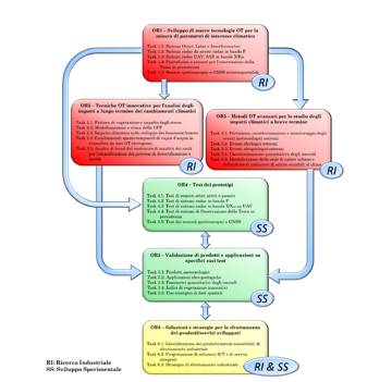
The general objective of the OT4CLIMA project is that of develop new measurement tools and new Earth Observation methodologies to provide products / applications / services aimed at improve mitigation capabilities of the Effects of Climate Change (CC) at the regional and sub-regional scale.Description
The project stems from the awareness that the impacts of the CCs in place on the environment and the territory need to be better understood, modeled and observed, even at the local and regional scale, in order to implement appropriate and effective mitigation strategies. It tries to respond to some of the challenges still open, identified by the main international initiatives (eg CEOS WG Climate, GCOS) as Recommendations and Actions for the next few years such as, for example, the use of new observation technologies, observation of additional climatic parameters as well as development of new analysis techniques (Cfr. GCOS 2016 Implementation Plan).Aims
OT4CLIMA, without claiming to address the problem as a whole, intends to contribute on specific phenomenological areas (water cycle and carbon cycle), parameters, observables and environmental matrices. In particular, both medium-long term impacts (eg vegetation stress, drought) and extreme events with rapid evolutionary dynamics (eg intense meteorological phenomena, fires) will be studied by attempting a double technological innovation, of "product" and " process". The project, for example, will make it possible to measure, with unprecedented methods and accuracy, atmospheric (e.g. the OCS, carbonyl sulphide) and surface (e.g. the water content of soils) parameters that are crucial in the determination of the contribution of vegetation to the CO2 balance, while proposing solutions, based on the analysis and integration of observational data acquired from satellite, airborne and unmanned platforms, to significantly improve the ability of local communities to deal with the effects of Short and long term CC.Participants
The project team consists of a solid public-private partnership with a strong presence in the European and national research and innovation system in the Aerospace sector, equipped with a wide range of Research Infrastructures of high scientific and technological value and with over 200 researchers who carry out research activities in the territories to which they belong, mainly located in the regions of Southern Italy (Basilicata, Calabria, Campania, Puglia, Sicily). In many of these regions, Aerospace is present as a priority for Smart Specialization Strategy making the link with local industrial policies particularly strong. In detail, the proposing public-private partnership is composed as follows: Research Bodies and Universities:- National Research Council (CNR), (coordinator) through the following Institutes: IMAA, IREA, ISAC, INO, IFAC, IRPI, IGG, IRET, IMM, ISAFOM, IBIMET, IAC, IIA, SPIN;
- University of Basilicata (UNIBAS);
- University of Calabria (UNICAL);
- University of Trento (UNITN);
- Italian Space Agency (ASI);
- National Institute of Geophysics and Volcanology (INGV)
- Big business:
- e-Geos of the LEONARDO group (EGEOS);
- Systems Engineering (IDS)
- PMI:
- CREATEC Consortium, part of the Technology District of Basilicata Technologies for Earth Observations and Natural Risks (CREATEC), through the following SMEs as actuators:
- GEOCART
- INNOVA
- PUBLISYS
- OPENET
- DIGIMAT
- SYNTHESIS
- CEDAT EUROPE
- Research Consortium on Advanced Telesensor Systems (CORISTA);
- Survey Lab (SURLAB);
- Integrated Intelligent Systems - Ligurian Technological District (SIIT), through the following SMEs as actuators:
- GTER
- STEM
- CREATEC Consortium, part of the Technology District of Basilicata Technologies for Earth Observations and Natural Risks (CREATEC), through the following SMEs as actuators:
Head of CNR-IIA
Sabino Maggi
Scientific manager
Email: sabino.maggi@iia.cnr.it
Working group
Sabino Maggi
email: sabino.maggi@iia.cnr.it
Christine Tarantino
email: cristina.tarantino@iia.cnr.it
Xavier Vicar
email: saverio.vicario@iia.cnr.it
Maria Patricia Adam
email: adamo@iia.cnr.it
Fabio Michele Rana
email: fabiomichele.rana@iia.cnr.it